
THIRUVANANTHAPURAM: Bringing an end to the anticipation, the Southwest Monsoon has officially arrived in Kerala. According to the India Meteorological Department (IMD) bulletin released at 1:30 PM, the monsoon made its entry into the state today, June 4.
The weather department has warned that the onset will bring widespread rainfall, thunderstorms, and strong winds across Kerala and Mahe over the next five days.
Multiple Weather Systems Active Across the Region
The IMD confirmed that the advance of the monsoon is being driven by several active cyclonic circulations and atmospheric troughs over the Arabian Sea and neighboring states:
- Goa Coast: A cyclonic circulation is currently hovering over the mid-east Arabian Sea, right off the Goa coast.
- Atmospheric Trough: A low-pressure trough has formed stretching from Marathwada in Maharashtra down to the southwest Arabian Sea, passing over the Konkan-Goa region at an altitude of 5.8 km above sea level.
- Bay of Bengal & East Coast: Additional cyclonic circulations are active over South Telangana, adjoining coastal Andhra Pradesh, Yanam, and the North Andaman Sea.
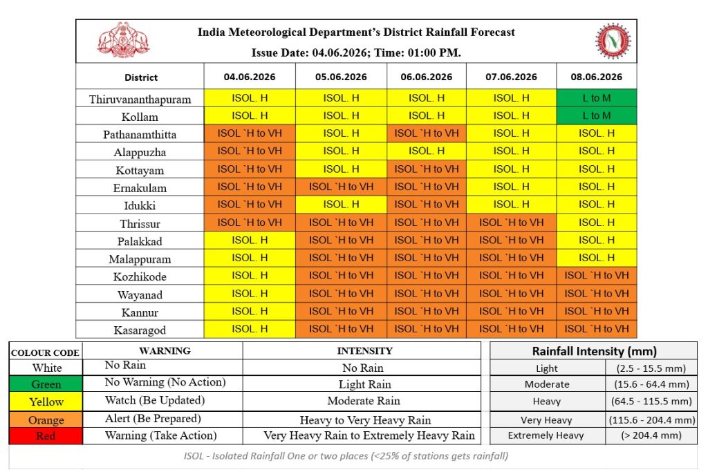
5-Day Rainfall and Wind Forecast (June 4 – June 8)
Under the influence of these interconnected weather systems, Kerala is bracing for intense weather conditions. Local administrations have been advised to stay vigilant.
- Heavy to Very Heavy Rainfall: Isolated regions across Kerala and Mahe are highly likely to experience heavy to very heavy downpours between June 4 and June 8.
- Squally Winds: Widespread rain will be accompanied by severe thunderstorms and lightning.
- Wind Speed: Surface winds are expected to gust at speeds ranging from 40 to 50 km/h.
Safety Advisory: Residents in low-lying areas and fishermen are advised to track local weather updates closely due to the sudden spike in wind speeds and potential waterlogging.


